By Hendrik van Oss
Participants: Hendrik van Oss, Gary Quam, Ginny Quam—all OC1s.
The Thornton and Hughes rivers offer classic Class II/II+ runs on the somewhat infrequent occasions when they have sufficient water. Usually, the Thornton requires more water than the Hughes, but in several of more recent trips on the Hughes (not for 2 (?) years) at near-canoeing zero levels, checks afterwards of the RC gauge at the Thornton put-in (Fletchers Mill) revealed levels several inches above zero. With a forecast for substantial rain Thursday and Friday, a trip was envisioned for Saturday (June 12), with a preference still for the Hughes, as neither of the Quams had yet paddled it. Very heavy rainfall on Friday yielded very strong peaks on the relevant USGS gauges, but showed precipitous drop-offs underway in the late evening that projected to good levels for Saturday. The gauges early Saturday morning showed that the rate of fall-off had slowed significantly late Friday night and it was thus felt prudent to postpone the trip until Sunday.
After meeting at 9:30 AM at the McDonalds (closed except for take-out) in Warrenton, we drove to Fletchers Mill (essentially on the way to the Hughes) and there found the RC gauge (10 AM) showing +4”—so we knew we had water on the Thornton. We continued to the Rte 522 bridge takeout for the Hughes/Hazel rivers (the Hughes is a tributary of the Hazel) only to find, to my surprise, that the little access road to the takeout area under the bridge was gated (and chained) shut—said gate and adjacent trees were festooned with No Trespassing signs. A quick visual inspection showed the takeout to be a muddy mess—clearly having been underwater but hours earlier—and that the “upstream” RC gauge read +1.5 ft. There being no other access points nearby, we decided that we could still run the top 4 miles of the Hughes down to the Rte 644/Reva Rd low water bridge, and so went there to drop off one truck. Both Reva Rd low water bridges (first Hazel, then Hughes) showed signs of having been flooded; the Hughes River bridge sported a major logjam (see photo), but a safe takeout existed at a small shingle bar in slow water on river left a few yards upstream of the logjam. While we were inspecting matters, a local came by on a motorcycle and explained that the rainstorm had dropped more than 9” in a short period and had flooded everything in the Hughes and Hazel catchments, but that the Thornton catchment had received a lot less rain. Worried about possible strainers upstream on the Hughes, we decided to run the Thornton instead. We set up shuttle at the usual takeout (Rock Mills) and got back to the Fletchers Mill put-in ~11:30 AM—the RC gauge still was 3” - 4”. The rapid at the put-in looked a bit bony (but it always looks bony)—what I should have noticed is that I could wade out in shallow water while getting into my canoe (normally, the water is moderately deep and swift immediately adjacent to the put-in), indicating significant cobble or shingle deposition since my previous trip. We launched around Noon.
The first rapid was, indeed, bony as expected…not to worry. The next several rapids also were scrapy, as were the next several, and as we convened in a convenient eddy, we agreed that the river was concealing its +3” remarkably well. And, indeed, we bumped and scraped pretty much the whole way down, and had to briefly get out and drag over one cobble bar. The ledge rapids were highly technical, but not pushy. One canoe experienced a temporary broach (w/o damage) on a boulder-ledge rapid. Prepare to Meet Thy God rapid (the largest single rapid on the run) displayed a seemingly well-established channel on the left side gravel bar—this used to be runnable only in significantly higher water. The long-standing run down the middle was now naked, dry rock, and the technical III- tight ledge run on the right was still there but insufficiently wetted for consideration.
No real hazards were present. Perhaps 1-mile into the trip, we had to portage a large downed tree, but there was plenty of time to pull out on river right for this brief labor. The tree might be runnable on the far left in higher water. We experienced light rain for the final half-hour of the run and both Gary and Ginny were scraping so much that I, some yards ahead, thought I was hearing distant thunder. The rain picked up in earnest as we loaded the canoes at the takeout. Back at the put-in (c. 3 PM), the RC gauge was still reading about +4”.
As water levels for these two rivers are a real issue, and very sensitive to localized rain conditions, the USGS gauge levels for them in the leadup to, and during, the trip might be of interest:
Hazel River—Rixeyville: Ettinger’s zeros are 650 cfs for the Hughes and 750 cfs for the Thornton.
Date Time Start of day End of day Comment
6/11 900 cfs 2,000 cfs Sharp peak 12,000 cfs c. 6 PM.
6/12 2,000 cfs 1,000 cfs dropping steadily
6/13 1,000 cfs ~ 780 cfs
7:45 AM 876 cfs
10 AM ~ 850 cfs Fletchers Mill RC ~ + 4”
11:30 AM ~ 810 cfs ditto RC slightly < 4” (call it 3”)
3 PM ~ 800 cfs ditto RC still about +4”
Battle Run: Ettinger zeros are minimum of 60 cfs for the Hughes and min. 70 cfs for the Thornton.
Date Time Start of day End of day Comment
6/11 500 cfs 80 cfs (“vertical” spike c. 9 PM 6/10 ~ 950 cfs!)
6/12 80 cfs ~ 42 cfs
6/13 ~ 42 cfs ~ 31 cfs
7:15 AM 38.3 cfs
10:30 AM ~ 38 cfs
11:30 AM ~ 37 cfs
3 PM ~ 35 cfs
Robinson River: Ettinger zeros are: minimum 450 cfs Hughes, minimum 500 cfs Thornton.
Date Time Start of day End of day Comment
6/11 350 cfs ~ 1,300 cfs (spike in late morning of 12,000 cfs!)
6/12 ~ 1,300 cfs ~ 650 cfs
6/13 ~ 650 cfs ~ 430 cfs
7:45 AM 550 cfs
10 AM ~ 540 cfs
11:30 AM ~ 520 cfs
3 PM ~ 480 cfs
Verdict: Ettinger zeros (except Battle Run?) were not good predictors for the Thornton given the very localized intense rainstorm(s). The Fletchers Mill put-in RC gauge is now reading about 3 – 4” too high; likely due to cobble deposition at the bridge.
.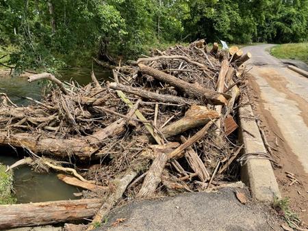
This Jam is at the first T.O. for the Hughes. Rte 644, Reva Rd.